Introduction
This is a series of tutorials and practical flying exercises prepared by CIX VFR Club to introduce members to online ATC and to enable them to learn at their own pace how to use it. Each lesson consists of a Groundschool section on aviation law and theory, and a practical exercise. From lesson 6 onwards, a discussion on flight planning is included and the practical exercise is a flight using the information in the lesson.
First Land Away
You have now done at least one short trip out and back from an aerodrome, online, with an Air Traffic Controller to talk to. You have been tongue-tied, and said all the wrong things in spite of rehearsals and you are beginning to wonder if it is all worthwhile. Everyone who goes into Flight Simulator on line has exactly the same experience, let me assure you.
You are going to fly from Wolverhampton to Gloucestershire and 'land away' as it is called. The descriptions in this lesson are comprehensive, 'hand holding' if you like, so that by the time you have read through the document, you will be able to fly the detail without any difficulty, provided you follow exactly the instructions given.
Groundschool
Reading
To help planning the flight, study exercise 17 section 5 of the CIX VFR Club Flight Training Manual. To help departure and arrival procedures at the aerodromes, study exercises 18, 19 and 20 of the Flight Training Manual.
The essential ATC dialogue for this flight is included later in this lesson, but you should also read Chapters 1, 2 and 3 of the Club's Radio Telephony Manual which may also be found on the web site on the same page.
As a new pilot, be aware that most controllers you are working are unlikely to be as inexperienced as you, although some may be. Obey their instructions, and ask for help if you are unsure of what to do. You can also put 'Student Pilot - first on line flight' in your flight plan. Also, read the Club 'Code of Conduct' document accessed from the Membership page of the web site. It contains a lot of useful advice.
Weather
This subject is introduced here because in VFR flight, the very first consideration is always the weather. Is it suitable for VFR yes or no? If yes, continue with this lesson, if no - go and do something else until another time, unless you want to switch off the weather again, as we did in Lesson 6.
Where do you get weather information from? You can get weather reports direct from FSInn, or from the Controller's text ATIS on Servinfo or VATSpy.
The FSInn Weather Window
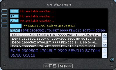
In FSInn, click on the Wx button on the main Control Panel to display the weather window. FSInn preferentially gives you the weather at your current location and then at the destination as entered in your flight plan, but it also shows any other available weather stations in your area. Click on the ICAO code of any to display the weather in standard ICAO code in a larger font in the lower part of the window.
The weather shown here in blue and copied below is for Inverness (EGPE) where the aircraft was at the time this screenshot was taken.
EGPE 290950Z 17018KT 9999 FEW010 SCT044 05/00 Q1010
Let's decode it.
Inverness 29th January 2009 at 09:50 UTC Wind 170° 18knots Visibility 10 kilometres or more, Cloud, few at 1000 feet, scattered at 4000 feet Temperature +5° Dewpoint 0° QNH 1010
For Squawkbox, to get a weather readout, you will need to use Servinfo or VATSpy. Open the application and click (VATSpy is a double-click) on the Airfield code, Controller's name or Position name and a small window appears which includes information about the weather at that Airfield.
But if there isn't a controller on duty for the area where you are flying, what then? There are many real world sources, and since VATSIM uses real world weather, then you can use these if you wish. Not the simplest perhaps but the official source is the Meteorological Office's Services for General Aviation: - http://www.metoffice.gov.uk/aviation/ga.html You need to register to access its information, but registration is free and there is no restriction preventing Flight Simmers from using the service.
A much easier site to use is xcweather at http://www.xcweather.co.uk
There is no need to register and full instructions are set out on the opening page. Just clicking your mouse at any point on the map will give you the current and forecast aviation weather for that point. A Preferences box on the left of the page allows you to change the wind speed display from mph to knots. Also change the wind Observation Direction from 'Compass' to 'Deg' (degrees), and Raw Data from 'No' to 'Yes'. These changes are remembered by a 'cookie' downloaded to your computer.
The xcweather website
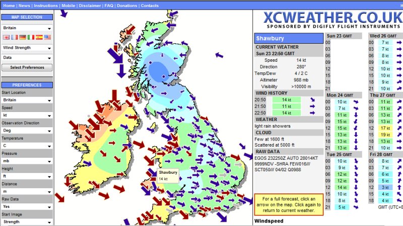
On this screen, I clicked on Shawbury. You can immediately see the current wind speed and direction, altimeter, visibility, weather and cloud information. Also included is the Raw Data, which may be unfamiliar but effectively gives the same information. On VATSIM, it is this encoded weather data which you will see, so you need to be able to decode it.
First lets look at the raw data:
EGOS 232250Z AUTO 28014KT 9999NDV -SHRA FEW016/// SCT050/// 04/02 Q0988
This means 'Shawbury 23rd (Nov 08) at 2250Z : Wind 280o 14knots : Visibility 10Km or more : Rain showers : Cloud Few at 1600 feet Scattered at 5000 feet : Temperature 04o Dewpoint 02o : QNH 988
This is exactly what it says in words above the Raw Data box. The word AUTO means that it is an automatic weather station, and NDV means 'No Directional Variation' which is added to winds on automatic weather stations only. You can safely ignore those two terms.
There are basically two types of information 'Terminal Area Forecasts' (TAFs) and Meteorological Actual Reports (METARs). They are similar, but we only really need worry about METARS on VATSIM. Decoding isn't difficult once you know the system, and there is an excellent explanation of METAR decoding at http://www.homepages.mcb.net/bones/01UKAV/METAR.htm
The official Meteorological Office glossary of terms may be found at http://secure.metoffice.com/aviation/abbreviations.jsp
From that information, we can see that the weather is satisfactory for VFR - no strong winds and no low cloud. For now we only need to make a note of the wind speed and direction.
Flight Planning
The next stage is to plan the flight. If you have access to a copy of one of the VFR Flight Guides, and a copy of the Southern England Half-million aeronautical chart, then get them out now. If you do not, then you will have to print out the small extracts included in this tutorial, or use a road map, and download the Wolverhampton and Gloucestershire Airport diagrams from the NATS web site.
You should also have exercise 17 section 5 of the CIX VFR Club Flight Training Manual to hand, so that the following sections make sense.
Distance
The map reproduced below is at roughly the right scale. You can buy an aeronautical scale rule from Flight Equipment suppliers such as Transair, or make your own. 0.1448 inches on a rule represents 1 one nautical mile on the chart, or 1.45 inches (3.6 centimetres) represents 10 nautical miles. It so happens that 1.45 inches is roughly the length of your thumb from tip to the first joint, and I use that regularly when estimating distances on the chart. However you choose to measure the distance from Wolverhampton to Gloucestershire, it is 37 nautical miles.
True Track and Bearing
Be very clear in your mind regarding the difference between Heading, Track and Bearing, and True and Magnetic Heading. The definition of all these terms can be found in Exercise 18a of the Club's Flight Training Manual, which you have downloaded and read, of course.
The Chart showing the Route
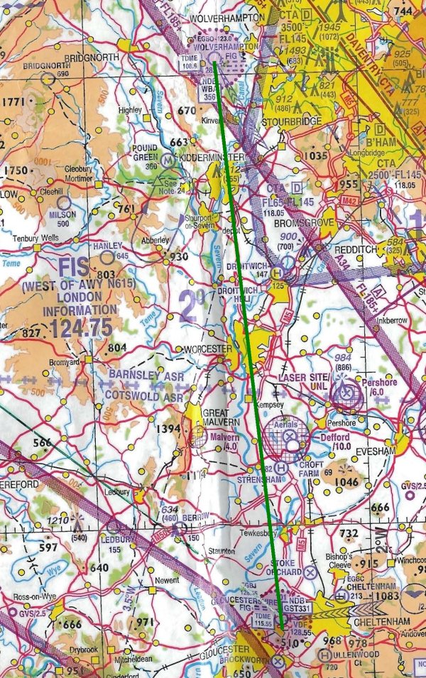
Your Route
At the top of this chart fragment is Wolverhampton (EGBO) indicated by a small blue circle surrounded by a larger one with a maroon dotted outline. The larger circle is the 4 nautical mile diameter Aerodrome Traffic Zone (ATZ) which we discussed in Lesson 2. Next, note that the route shown by the green line passes overhead Kidderminster and Worcester - big towns which make very good waypoints.
South of Worcester and east of Great Malvern there is a circular hatched area labeled 'Defford' The hatched symbol means that that is an area of strong radio transmissions and you should avoid it. So in that area, make sure you fly a little further west of the drawn track - stay nearer the River Severn than the M5, which lie either side of your route in that area. Finally note that the route crosses the M50 about 9 miles north of Gloucesterhire.
As recommended in Exercise 17 of the Club's Flight Training Manual, I used a permanent green marker pen (e.g. Lumograph) to draw the 'track line' from Wolverhampton to Gloucestershire. Using a protractor, I measured the angle of the track line relative to the vertical lines of longitude marked on the chart, which run north south. I find that this angle - the true bearing - of the line is 174o, and that is also my intended True Track.
Magnetic Track
It is time to learn another of aviation's many mantras.
Variation east, magnetic least. Variation west, magnetic best
Magnetic variation is the difference between true north and magnetic north. In this part of Britain it is 4 degrees west at the moment, (it changes slowly over time).
Why is that important? You saw above that the true track, measured against the lines of longitude on the map, is 174o, but your compass and Direction Indicator indicate Magnetic bearings. Magnetic variation is 4o west so you need to add it to the true bearing, because the magnetic bearing has to be 'best', i.e. greater than the true bearing. Your Magnetic Track is therefore 178o.
A few years ago, the Flight Simulator world saw the launch of Plan-G, a remarkable, feature rich flight planning tool based on Google Maps, which makes flight planning not only very easy, but also an enjoyable part of the whole Flight Simulator experience.
In addition, the Club has a simple Microsoft Excel 2000 flight planning spreadsheet on the website. It was originally designed for use in real world recreational flying. It includes full instructions for use. Both of these applications are available on the Club website
For this lesson, we will use the Flight Planner Spreadsheet. On the Outbound and Inbound tabs you enter your route data in the white boxes, and the answers are displayed in the yellow boxes. The Pilots Log tab can be printed out, and used during flight. For Flight Simulator, you might prefer the somewhat simpler examples illustrated in Lesson 5.
The Club Flight Planner Outbound Page
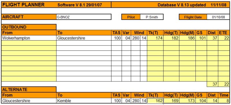
For this flight, it can be as simple as entering the two aerodromes, the true airspeed (TAS), Magnetic Variation (Var) and wind. If the true airspeed is 100 knots (for altitudes below 5,000 feet take it that it is the same as Indicated Airspeed), and the wind is 280o at 14 knots, the Planner calculates your true track (Tk*(T)) as 174o confirming the value you measured, the true heading and magnetic heading (the heading to steer), which is 186o.
Note that if you spell an aerodrome name wrongly, then it won't be found in the database and the Planner will just return a run of '###'s in the calculated fields.
However, when you are unused to flying by reference to ground features, then it is very comforting to use intermediate waypoints to check your progress and the accuracy of your track. Kidderminster and Worcester have already been mentioned. The M50 where it crosses over the River Severn is also an important point as that is where you will first contact Gloucester ATC. The instructions which are included in the Flight Planner download tell you how to add such 'User Waypoints', so have a try. Kidderminster and Worcester are already in the Flight Planner User Waypoint database (Version 8.13) so the flight plan below includes those two.
User Waypoints added to the Flight Plan
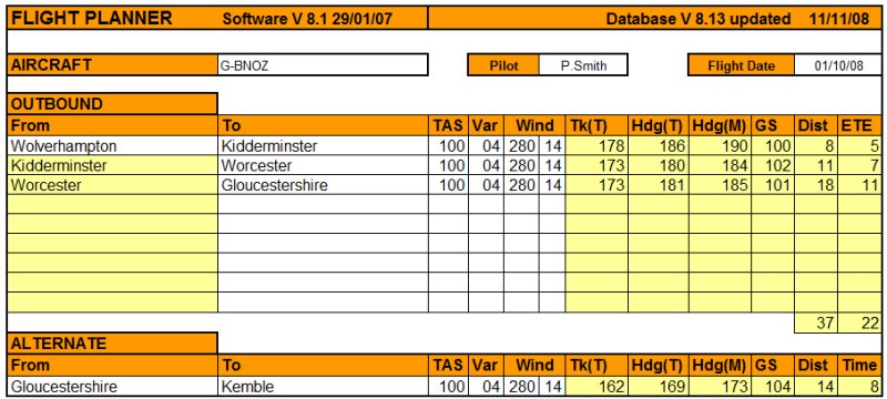
Note that the headings shown are slightly different. This is because the Latitude and Longitude entered in the Planner's database for these towns is not precisely on your straight line track, but differences of 3° or 4° are not significant over these short distances. Trust me, fly within ± 5° of the planned heading and you will not miss these two towns.
Airspeed and Altitude
Looking at the chart and the METAR information, you can see that you can fly the route at an altitude of 2000 feet. That will be a safe altitude to avoid hitting high ground to the west (shown brown on the chart) and avoid controlled airspace round Birmingham to the east. It will also keep you below cloud. The normal cruising speed of the Cessna 172 is 100 knots, so perhaps you can calculate the en route time for the 37 miles.
37 miles at 100 knots takes 37/100 x 60 minutes = 22.2 minutes
However, the wind could be slowing you up or pushing you along. In this example, wind is broadly from your right, so the head or tailwind component is insignificant, and the Flight Planner indicates 22 minutes, so you should accept that figure.
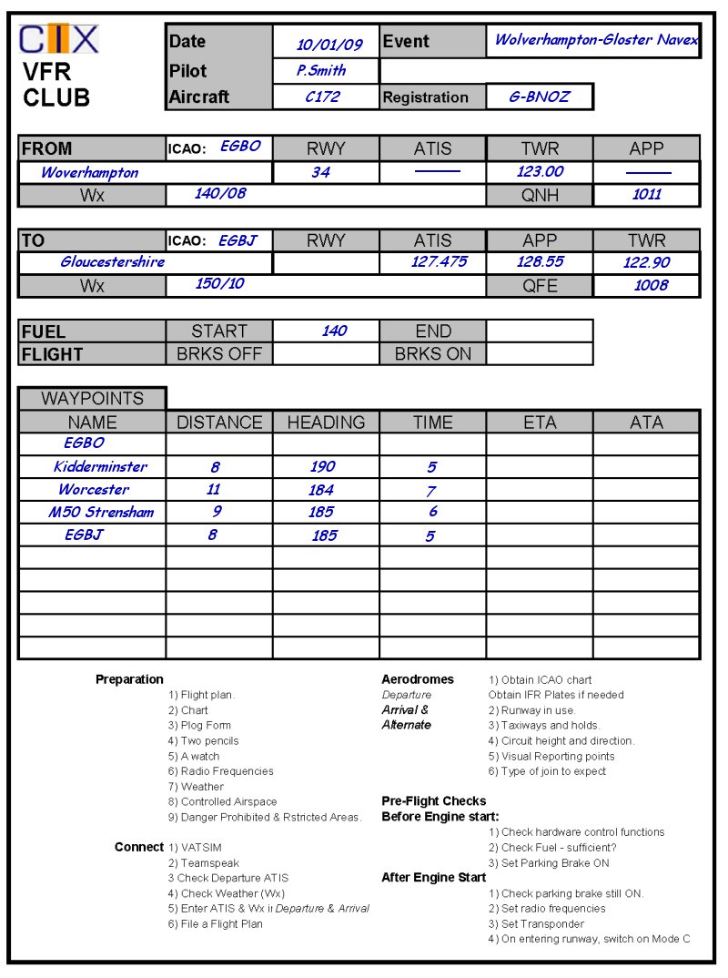
Fuel
| FUEL | |
| Element | Minutes |
| Taxiing at Wolverhampton | 5 |
| Take off and climb | 10 |
| En route | 25 |
| Taxiing at Gloucester | 5 |
| Reserve | 45 |
| Total | 90 |
You need to decide how much fuel you need. From the method given in Lesson 5 you can calculate what is needed. Your flight time is 22.2 minutes, say 25 minutes, but that's not all. We need to allow 10 minutes for taxiing at both ends and 10 minutes for the take off and climb to 2000 feet.
Here is the fuel calculation: -
At 30 litres per hour fuel burn, that's 45 litres required. The Club Flight Planner Pilot's Log page has a small box at the upper right for fuel. You can see that the Planner estimates that 57 litres are needed, because it allows 20 minutes total time for taxiing, and includes 1 hour reserve rather than 45 minutes..
That's Heavy, Man!
Fuel is heavy, and if you have 3 hefty fellows in a C172 and full tanks, you will be at maximum takeoff weight, I can assure you. (I know the C172 has 4 seats). If you set Flight Simulator to have only yourself on board in the Aircraft Fuel & Payload section, then yes you can start off with full tanks, but just look what happens if you try and put in 4 people each weighing just 12 stones (76.2 kilograms) and full tanks! Mr Cessna was an optimist! You are only 33kg under maximum weight with just three 12 stone people on board and full tanks. For this trip, however, to keep things simple, just put yourself in the aircraft and full tanks. We will cover weight and balance, as this topic is known, in more detail in a later lesson.
The Pilot's Log
So the planning is over. You are almost ready to fly now. You know where you are going, the heading and the altitude; you know what waypoints you are going to look out for; you know how long the flight will last and how much fuel you have on board. The last thing we need to do is to make up your pilots log or Plog, and you update it throughout the flight. You can use any of the examples shown in Lesson 5, download the ones from the Club web site, or design your own.
All ready to go? Then just go fly!
Practical
Rehearsal
Before you take to the skies, think through what will happen on the flight. Be Prepared is as good a motto for pilots, even simulating ones, as it is for Boy Scouts. So for this flight, you might prefer to do a 'dry run' off line. Make sure you log your progress on your PLOG - take off time, your time overhead Wolverhampton, your times over Kidderminster, Worcester and crossing the M50, then your landing time. When you fly the trip on line, make sure too that you put 'CIX VFR Club Student Pilot' in your VATSIM Flight Plan.
Checklist
Don't forget to work through your checklist.